The government recorded a new public square and sections of promenade opening in July 2026. Verify the exact entrance, crossings and current works around a listing.
MSIDA · THREE CONTEXTS
Creek, streets, campus.
Read Msida through the exact address: the parish-waterfront edge, the inland streets behind it, then Tal-Qroqq and the university campus uphill.
START WITH THE EXACT STREET
One locality, different routines.
The Local Council records Msida's shift from fishing settlement to university town. That shared identity does not make a Valley Road home a waterfront address or place every creek listing beside the campus.
Valley Road and the older inland grid need their own grocery, clinic and transport check rather than a harbour assumption.
The University of Malta's main campus is in Msida, but elevation and junctions make a property-specific route more useful than a locality-wide walking claim.
A changing public edge.
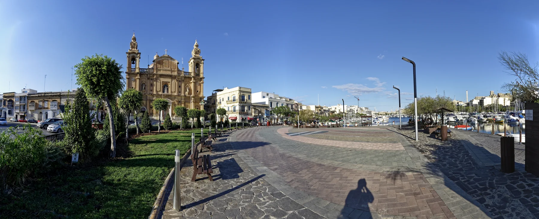
The waterfront panorama gives orientation around the parish church, marina and open harbour space. It does not prove a view, quiet interior, easy parking or completed works for any property.
Government project update ↗A campus context uphill.
The University identifies its main campus at Msida MSD 2080 and publishes a separate campus map. This edition keeps campus orientation distinct from the creek and assigns no commute time without a real property origin.
University campus information ↗OFFICIAL AND OPERATOR-VERIFIED EXAMPLES
Everyday anchors, without a ranking.
These examples help place practical life around Msida. They are not claims that a venue is the best, closest or suitable for every property, and current hours remain on the linked source.
Msida Community Clinic
Primary HealthCare lists the clinic at the Local Council in St Augustine Street. Service schedules and appointment rules stay with the official directory.
Official clinic directory ↗Welbee's Campus
The operator lists its supermarket at the University of Malta, Tal-Qroqq, Msida. Distance and route still depend on the property.
Operator store locator ↗University of Malta
The University identifies its main campus as Msida MSD 2080 and publishes a dedicated campus map. Entrances and facilities should be checked there.
Official campus information ↗Msida Local Council
The council publishes its current locality information and services. Its office is also the address named in the official community-clinic directory.
Official council page ↗FOUR DISTINCT MSIDA CONTEXTS
Creek, old streets and campus need separate checks.
These are ways to understand the locality, not a pre-drawn itinerary. Current crossings, project works, opening rules and the usable entrance remain a live check.
Read the July 2026 opening precisely
The government records a new public square and sections of waterfront promenade opening on 13 July 2026. It also says other project works continued, so this page does not call the whole scheme complete.
Dated government update ↗Observe the real harbour edge
The parish church, marina and main-road environment form one recognisable Msida scene. Verify the exact entrance and current crossing rather than inferring access from the panoramic photograph.
Local Council context ↗Find the older inland settlement
The council distinguishes the older settlement around Valley Road and nearby roads from later urban growth. That lived-in grid is not interchangeable with the creek or campus.
Council geography and history ↗Use the University campus map
The campus has its own entrances and facilities uphill from the waterfront. The University's current map is useful for orientation but does not establish a walking time from a property.
Official campus map ↗12 CURRENT LICENCE RECORDS
Examples grouped by address context, not taste.
The MTA's MSIDA filter returned 12 restaurant records when reviewed on 27 October 2026. A record verifies a licensed name, reference and recorded address only—not quality, menu, hours, reservations or proximity to a home.
Amami Food · Cuba
The register lists Amami Food as RST-27011 and Cuba Restaurant as RST-27161 at Campus Hub on Triq l-Universita. They illustrate the campus setting, not a ranking.
Filtered MTA register ↗Indian Harvest · Shakinah
Indian Harvest appears as RST-25248 on Xatt l-Imsida; Shakinah appears as RST-22748 at 12 Ix-Xatt Ta' Xbiex, Msida. The records establish addresses, not a continuous walking route.
Review all 12 records ↗Tal-Begig · Yoshi Sushi
Tal-Begig is recorded as RST-13397 at 104 Triq il-Wied ta' l-Imsida and Yoshi Sushi as RST-31542 at 68/69 Triq Misrah il-Barrieri. Check operators for today's service.
Current Msida filter ↗No harbour shortcut.
This page draws no walking route, ferry line or commute time. Walking geometry, bus timetables, current car traffic and taxi-price observations are separate sources and must be checked from the exact origin, destination and observation time.
Open the Msida map only when you need it.
The overview includes the creek, inland streets and Tal-Qroqq campus context. It deliberately draws no council boundary, route or journey time and loads from OpenStreetMap only after your click.
Msida Local Council · Council geography and history · Office of the Address Registrar · University of Malta · University campus map · Government waterfront update · Primary HealthCare · Welbee's · MTA Msida restaurant register
No ranking, fixed opening hours, property-specific route, accessibility promise, guaranteed view, parking claim or locality-wide journey time is claimed.
Nexus Marketplace
Explore Msida
See local homes and explore food, shops and everyday places around the neighbourhood.
Homes in Msida
Browse local listingsPlaces around Msida
Mapped places within 2 km of the centre. This can include nearby neighbourhoods.